UAV mission planning software

UAV Mission Planning Software with 3D Mission Preview

Prepare repeatable UAV operations with route, altitude, coverage, scheduling, telemetry, and safety supervision in one mission workflow.

Mission capability

A connected system from operator intent to safe flight execution.

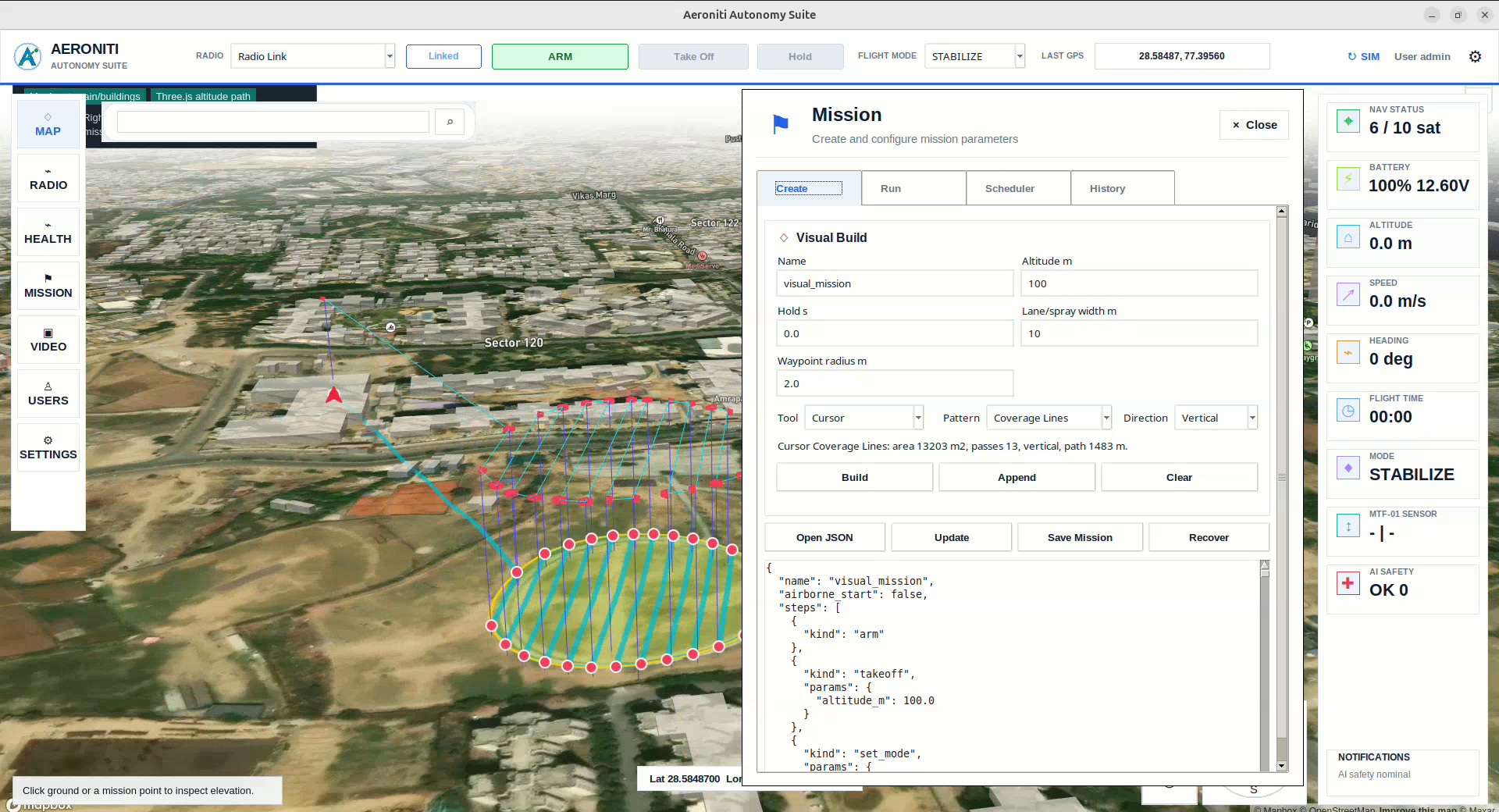
Plan UAV missions with 3D map previews, route planning, area coverage, altitude control, mission scheduling, telemetry monitoring, and supervised autonomous execution.

UAV mission planning software interface with three-dimensional route and waypoint preview

How the system works

Engineering UAV mission planning software around the mission.

Each layer is configured around the aircraft, operating environment, sensor stack, safety requirements, and level of human supervision.

System 01

Plan route, altitude, area, coverage, and stages

Build a mission around the work to be completed rather than isolated waypoints. Define route geometry, altitude behavior, coverage patterns, mission stages, sensor actions, and operating limits.

System 02

Preview behavior before takeoff

A 3D mission preview helps operators inspect the planned route and understand how the aircraft should move through the environment before committing equipment to flight.

System 03

Save repeatable missions

Approved plans can become repeatable operating templates for inspection, patrol, monitoring, mapping, research, or controlled-site field work.

System 04

Schedule autonomous operations

Mission scheduling connects saved plans with operational timing while preserving pre-flight review, readiness checks, and operator authorization.

System 05

Connect the mission plan to onboard AI

The plan provides structure for onboard perception and decisions. Detected obstacles, people, objects, or mission conditions can trigger bounded actions within the approved workflow.

System 06

Monitor telemetry and safety

Live position, flight state, progress, communications, and safety information return to ground control so the operator can supervise and intervene.

Frequently asked questions

Questions about UAV mission planning software.

Practical answers for teams assessing an Aeroniti mission configuration.

What can UAV mission planning software configure?

It can configure routes, waypoints, altitude behavior, area coverage, mission stages, schedules, sensor actions, and operating constraints.

Why use a 3D mission preview?

A 3D preview helps operators evaluate route geometry and altitude changes in context before the mission is flown.

Can a mission plan be reused?

Yes. Saved mission templates support repeatable operations and consistent operator procedures.

Can onboard AI change mission behavior?

AI can request bounded mission actions based on sensor input, while Pixhawk and ArduPilot retain flight-safety responsibilities.

Is mission scheduling fully unattended?

Scheduling is part of the workflow, but deployment should retain appropriate readiness checks and human supervision for the operating environment.

Request demo

Discuss your UAV mission planning software requirements.

Share the mission, aircraft, operating environment, sensors, payload, safety constraints, and expected outcome. Aeroniti can define a focused integration and field-validation path.

Request a Mission Review